
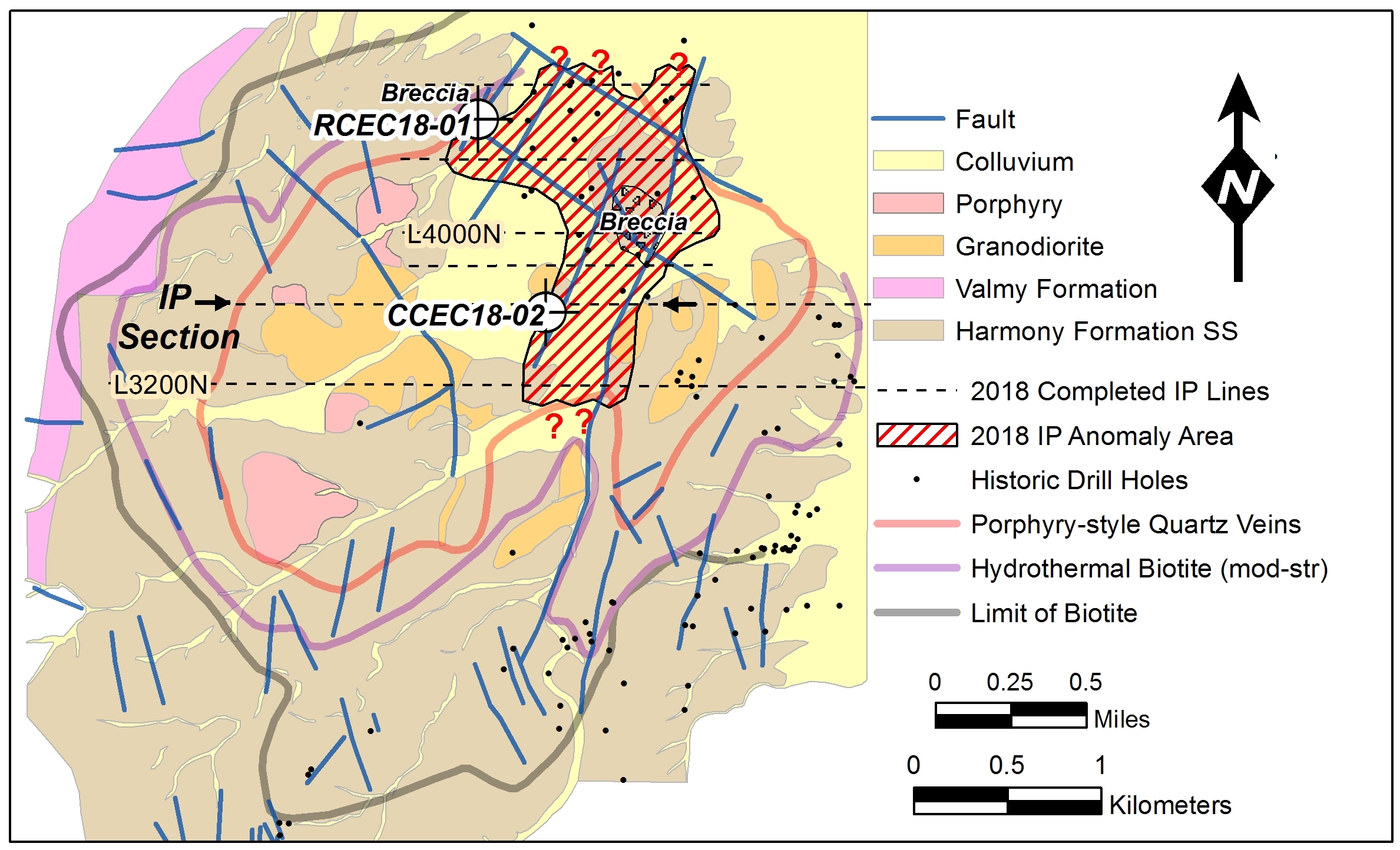
COEUR D'ALENE, IDAHO / ACCESSWIRE / January 8, 2019 / Timberline Resources Corporation (OTCQB: TLRS; TSX-V: TBR) ("Timberline" or the "Company") today announced results of an Induced Polarization /Resistivity (IP) geophysical survey (Figure 1) at the Elder Creek Project in Nevada's Battle Mountain mining district. The IP survey was completed in follow-up to drilling of core hole CCEC18-02 which intersected 14.2 meters (m) of 1.82% Cu, 0.31% Mo, 0.126 g/t Au, and 25.5 g/t Ag (Table 1) and, one kilometer to the northwest, reverse circulation (RC) drill hole RCEC18-01 which intersected 33.5 m of 0.44% Cu and 5.0 g/t Ag (see press release dated November 26, 2018 at http://timberlineresources.co/press-releases/). The strong IP anomaly appears to have been intersected at depth (Figure 2) concurrent with the best mineralization in the core hole. The RC hole was terminated above the IP anomaly due to drilling difficulties. Key conclusions of the IP survey include:
- The IP maps a distinct body of sulfide mineralization ≥1,600 m long and 500 - 800 m wide (Figure 1) within a very large (4 km) circular copper-molybdenum-gold-silver porphyry mineral system;
- The IP suggests that, although well mineralized, Timberline's drill holes did not test the strongest part of the large mineral system. Furthermore, historic drilling was too shallow (typically <200m depth) to intersect the anomaly. As such, the IP anomaly remains largely untested by drilling.
Figure 1. Elder Creek Project Area Geology, Alteration Zoning, and IP Anomaly
Steven Osterberg, Timberline's President and CEO commented, "The IP survey at Elder Creek defines a strong anomaly which is open-ended beyond 1.6 km length and is directly associated with porphyry-related iron-, copper-, and molybdenum-sulfides as documented in our recent drilling. One drill hole (CCEC18-02) appears to have clipped just the edge of, and the other (RCEC18-01) was terminated above the anomaly due to drilling difficulties. We recognize the strongest parts of the IP anomaly could represent a very large body of sulfide mineralization and that the drill holes did not test this very large mineral system. This is particularly exciting as the size and distribution of the anomaly, along with underlying geology recognized from mapping and drilling at Elder Creek suggests multiple geologic events which are key indicators of major porphyry copper systems. We look forward to follow-up drill testing in early 2019."
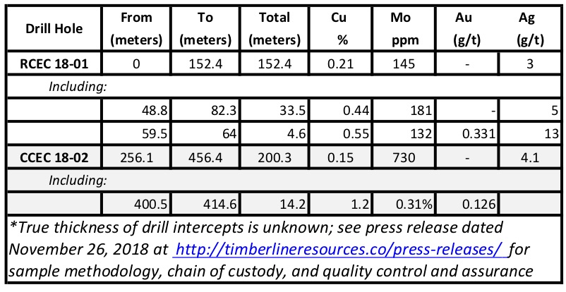
Table 1. Summary of Elder Creek 2018 Drilling Results
IP/Resistivity Survey
Zonge Geophysics of Reno, Nevada completed 6 lines (Figure 1) with approximately 13 km of IP survey using the dipole-dipole method which is effective in mapping subsurface concentrations of metallic sulfide minerals. The method was selected with generally 400 m line spacing and 200 m dipole separation to give a subsurface survey depth limit of approximately 500 m. The first survey line was completed over core hole CCEC18-02 to calibrate the geophysical response to sulfide mineralization intersected in the drill hole. Parallel survey lines were positioned to overlap the zoned porphyry-style stockwork quartz veins and hydrothermal biotite mineral alteration which help define the large size of the system.
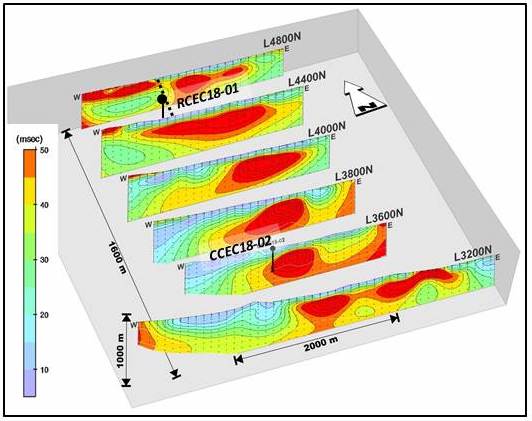
The IP data were processed by Zonge with a 2D Smooth-Model Inversion and presented in sequential depth sections (Figure 2) along the survey lines (Figure 1). The priority anomaly, as defined by high chargeability, extends from near surface to at least 500 m depth in places over a trend length of 1,600 m. The anomalies are generally open beyond the depth extent allowed by data processing.
Figure 2. Elder Creek IP Chargeability along Vertical Sections
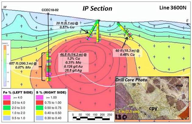
Drilling by Timberline (hole CCEC18-02) along Line 3,600 N (Figure 3) appears to have clipped the western edge of the priority IP anomaly where pervasively altered hornfels (after Harmony Formation greywacke and arkosic sandstones), porphyritic intrusive rocks, and hydrothermal breccias (see press release dated November 26,2018 at http://timberlineresources.co/press-releases/) were intersected. Sulfides occur throughout the hole, but are most concentrated from 400.5 - 414.6 m (1,313.5 - 1,360 feet) where they occur primarily as irregular veinlets, and as quartz-sulphide matrix to breccia which cross-cuts potassic-altered hornfels and associated porphyritic intrusions. The mineralization is polymetallic with sulfides of iron, copper and molybdenum.
The abundance of iron and sulfur in the drill hole CCEC18-02 intercept correlates well with the strongest chargeability (Figure 3) giving confidence that the IP method is successfully mapping a large sulfide body. Historic drill holes (see Elder Creek NI43-101 Technical Report at http://timberlineresources.co/)along Line 3600N stopped short of testing the IP anomaly, but nonetheless intercepted anomalous copper and iron sulfides above the IP anomaly.
Figure 3. Line 3600N IP Chargeability Anomaly and Drill Hole CCEC18-02 and Historic Drill Holes
Near the north end of the survey area, drilling by Timberline in hole RCEC18-01 between IP Line 4400N and Line 4800N (Figure 1) was terminated above the IP anomaly due to difficult drilling conditions. Nonetheless, drilling intersected 34 m (110 feet) of 0.44% copper in near-surface, altered hornfels within a broader interval (152 m; 500 feet) of 0.21% copper (see press release dated September 27, 2018 at http://timberlineresources.co/press-releases/), much of which is oxidized. The IP anomaly in this area is considered to remain untested by drilling.
Exploration Plans
The Company plans to expand the IP survey at Elder Creek and to resume drilling with targeting to focus on the priority IP anomaly and offsets of previous drill intercepts. Historic drilling was clearly focused on near surface targets with only rare drill holes deeper than 200 m vertical depth leaving the IP anomaly (Figure 1) effectively untested. The project is fully permitted with the US Bureau of Land Management (BLM) for an additional 43 sites for drilling. Pending available financing, geophysics and drilling will resume in 2019, Qtr 1.
Elder Creek Property
Timberline's Elder Creek and adjacent Paiute copper-gold properties lie within the prolific Battle Mountain District of Nevada, approximately 11 miles (18 km) north of Newmont's Phoenix mining complex. Data compiled from over 40-plus years of exploration on the property documents only shallow, historic drilling within a pronounced magnetic low considered to be the core of a large porphyry copper-gold hydrothermal system. Furthermore, only shallow drilling occurred along the north and northeastern magnetic zone and primarily targeted gold. Geologic and geophysical characteristics, and rock geochemical sampling results evident at Elder Creek (see press release dated June 18, 2018 at http://timberlineresources.co/press-releases/) are common to major porphyry copper deposits.
Steven Osterberg, Ph.D., P.G., Timberline's President and Chief Executive Officer, is a Qualified Person as defined by National Instrument 43-101 and has reviewed and approved the technical contents of this release. Mr. Osterberg is not considered independent of the Company as defined in Section 1.5 of NI 43-101. Drill intercepts are reported as drill thicknesses; true widths of intercepts are unknown.
About Timberline Resources
Timberline Resources Corporation is focused on advancing district-scale gold exploration and development projects in Nevada. These include its 23 square-mile Eureka property, comprising the Lookout Mountain, Windfall, and Oswego projects which lie along three separate structural stratigraphic trends defined by distinct geochemical gold anomalies, as well as being operator of both the Paiute joint venture project with a subsidiary of Barrick Gold, and the Elder Creek joint venture with McEwen Mining. All of these properties lie on the prolific Battle Mountain-Eureka gold trend. Timberline also owns the Seven Troughs property in Northern Nevada, which is one of the state's highest-grade former gold producers. Timberline has increased its owned and controlled mineral rights in Nevada to over 43 square miles (27,500 acres). Detailed maps and NI 43-101 estimated resource information for the Eureka property, and NI 43-101 Technical Reports for the Elder Creek and Paiute Projects may be viewed at http://timberlineresources.co/.
Timberline is listed on the OTCQB where it trades under the symbol "TLRS" and on the TSX Venture Exchange where it trades under the symbol "TBR".
Steven Osterberg, Ph.D., P.G., Timberline's President and Chief Executive Officer, is a Qualified Person as defined by National Instrument 43-101 and has reviewed and approved the technical contents of this release.
Forward-looking Statements
Statements contained herein that are not based upon current or historical fact are forward-looking in nature and constitute forward-looking statements within the meaning of Section 27A of the Securities Act of 1933 and Section 21E of the Securities Exchange Act of 1934. Such forward-looking statements reflect the Company's expectations about its future operating results, performance and opportunities that involve substantial risks and uncertainties. These include, but are not limited to, statements regarding the advancement of projects, and exploration potential. When used herein, the words "anticipate," "believe," "estimate," "upcoming," "plan," "target", "intend" and "expect" and similar expressions, as they relate to Timberline Resources Corporation, its subsidiaries, or its management, are intended to identify such forward-looking statements. These forward-looking statements are based on information currently available to the Company and are subject to a number of risks, uncertainties, and other factors that could cause the Company's actual results, performance, prospects, and opportunities to differ materially from those expressed in, or implied by, these forward-looking statements. There are no assurances that the Company will complete the earn-in on the Elder Creek project as contemplated or at all. Factors that could cause or contribute to risks involving forward-looking statements include, but are not limited to, changes in the Company's business and other factors, including risk factors discussed in the Company's Form 10-Q for the quarter ended June 30, 2018. Except as required by law, the Company does not undertake any obligationto release publicly any revisions to any forward-looking statements.
Neither the TSX Venture Exchange nor its Regulation Services Provider (as that term is defined in the policies of the TSX Venture Exchange) accept responsibility for the adequacy or accuracy of this release.
For Further Information Please Contact:
Steven A. Osterberg
President and CEO
Tel: 208-664-4859
E-mail: info@timberline-resources.com
Website: www.timberline-resources.com
SOURCE: Timberline Resources Corporation
View source version on accesswire.com:
https://www.accesswire.com/532093/Timberline-Identifies-Large-IPResistivity-Anomaly-at-the-Elder-Creek-Porphyry-Cu-Mo-Au-Ag-Project-Nevada
